I. Project Initiation
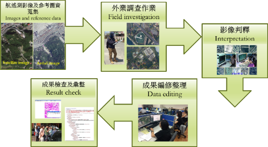
Land Use Investigation (LUI) is proceeded by digitizing the area of current land use showing up in aerial and remote-sensing imagery. Field investigations and records are also used to establish the current category of land use. The results of land use investigation provide an important reference for socio-economic development and land use planning.
The Ministry of the Interior (MOI) conducted a nationwide LUI during 1993 to 1995 as the basis for land planning. With vigorous global economic growth, domestic industries and the land use change also grow into higher complexity. In a densely populated and congested environment like Taiwan, it is imperative and of top priority to effectively use and manage land resources for achieving the purpose of sustainable land use. And the control of land use status is essentially the key to such operation. Therefore, Ministry of the Interior has mapped out a subproject of "Land use investigation plan" is contained in "National Geographic Information System Promotion and Implementation 10-year Plan" project, and commissioned the National land surveying and mapping center (NLSC) to organize and conduct the second nationwide LUI and result data integration including Taiwan and peripheral islands annually from 2006 to 2015.
In order to sustain a renewal and maintenance operation and continue the timeliness and applicability of LUI result. The MOI has formulated the "Implementation of the Smart Land - Land Surveying and Mapping and Maintenance Plan", and the "Land Use investigation" is one of the program period from 2016 to 2020.
In addition, in cooperation with “The Spatial Planning Act” and “The Regulations for Land use investigation” implemented on May 1, 2016 and January 1, 2020 respectively.The Spatial Planning Act specifies that the source of funding is the Spatial Sustainable Development Fund, therefore the program period is from 2020 to 2025.
II. Project Contents
The MOI conducted the first national land use investigation from 1993 to 1995 to provide a reference for national land planning policy. Due to widespread demand for information on current land utilization, the MOI directed the NLSC to conduct a second national land use investigation between 2006 and 2008. The investigation was completed by August 2009 and continued to carry out further updates by NLSC. The investigation of land use map is up to level 3 and covers 9 major categories, 41 sub-categories and 103 sub-sub categories including agriculture, forests, transportation, water, building, public facilities, recreation, mining/salt production and others. In order to integrate the LUI resources of all agencies, NLSC, the Forestry and Nature Conservation Agency (FANCA), Ministry of Agriculture (MOA) and the Agency of Rural Development and Soil and Water Conservation (ARDSWC) began combine resources to jointly maintain the results of LUI split across three areas of responsibility since 2012. To ensure the timeliness and usefulness of LUI results while taking the cost of updates into account, update frequency was shortened to 2 years from 2016 onwards. Investigation results will also be updated to level 2 in accordance with the amended land use classification system issued by the MOI on April 13, 2015.
In addition, in cooperation with “The Spatial Planning Act” and “The Regulations for Land use investigation” implemented on May 1, 2016 and January 1, 2020 respectively, MOI (handled by NLSC) and the Forestry and Nature Conservation Agency jointly handle the land use investigation in the land area, the Forest investigation is responsible for the scope of the FANCA. According to the land use classification system table (land area part, including 9 major categories, 48 sub-categories and 93 sub-sub categories), updating the results of the classification investigate to the 3rd classification every 2 years, and for the latest investigated results of the Forest Service that do not completely correspond to the classification items, the investigation will be supplemented to the same classification level, so as to facilitate the subsequent overall results statistics, data release and results circulation supply.


III. Anticipated Benefits
- Land is the base for people's livelihood and the development requirement. Land use investigation is the basis of national economic development. Through the comprehensive land resource survey census and the space development trends, land use investigation consolidate spatial planning information for the establishment of a spatial plan.
- The cooperation of authority units with the administrative process to update and maintain the land use investigation data by indeed, efficiently inter-departmental integration resources.
- Implement of Article 19 of the Spatial Planning Act. The authority shall survey land cover and monitor land use on a regular basis to provide land planning, land management, monitoring mechanism, ecological conservation, environmental protection and forest maintenance and other policies required for basic geospatial information.
- Through sharing the land use investigation data by every authority units can reduce the duplication of funds invested by the authorities, effectively achieve the sharing of resources, expand the use of efficiency, enrich the richness of the land planning database, so that the overall planning of land more reasonable, to achieve sustainable land management purpose.