To make flood simulation results more detailed, it is insufficient to rely solely on Digital Terrain Model (DTM) data in grid format, especially as decision-making needs evolve from regional to real-time community levels. Integrating three-dimensional terrain feature data can enhance both computational efficiency and the detailed representation of terrain information. To improve the quality of geomorphic data in two-dimensional flood models, starting from 2018, the Water Resources Planning Branch, Water Resources Agency, Ministry of Economic Affairs, has collaborated with the Ministry of the Interior(MOI). They have integrated Digital Elevation Model (DEM) data to produce the Hydraulic Digital Elevation Model (HyDEM), establishing the overall concept of the Hydrologic Topography Dataset (HTD) and formulating the "Guidelines for Measurement and Verification of Hydraulic Digital Elevation Data" as a basis for producing geomorphic data suitable for flood models.
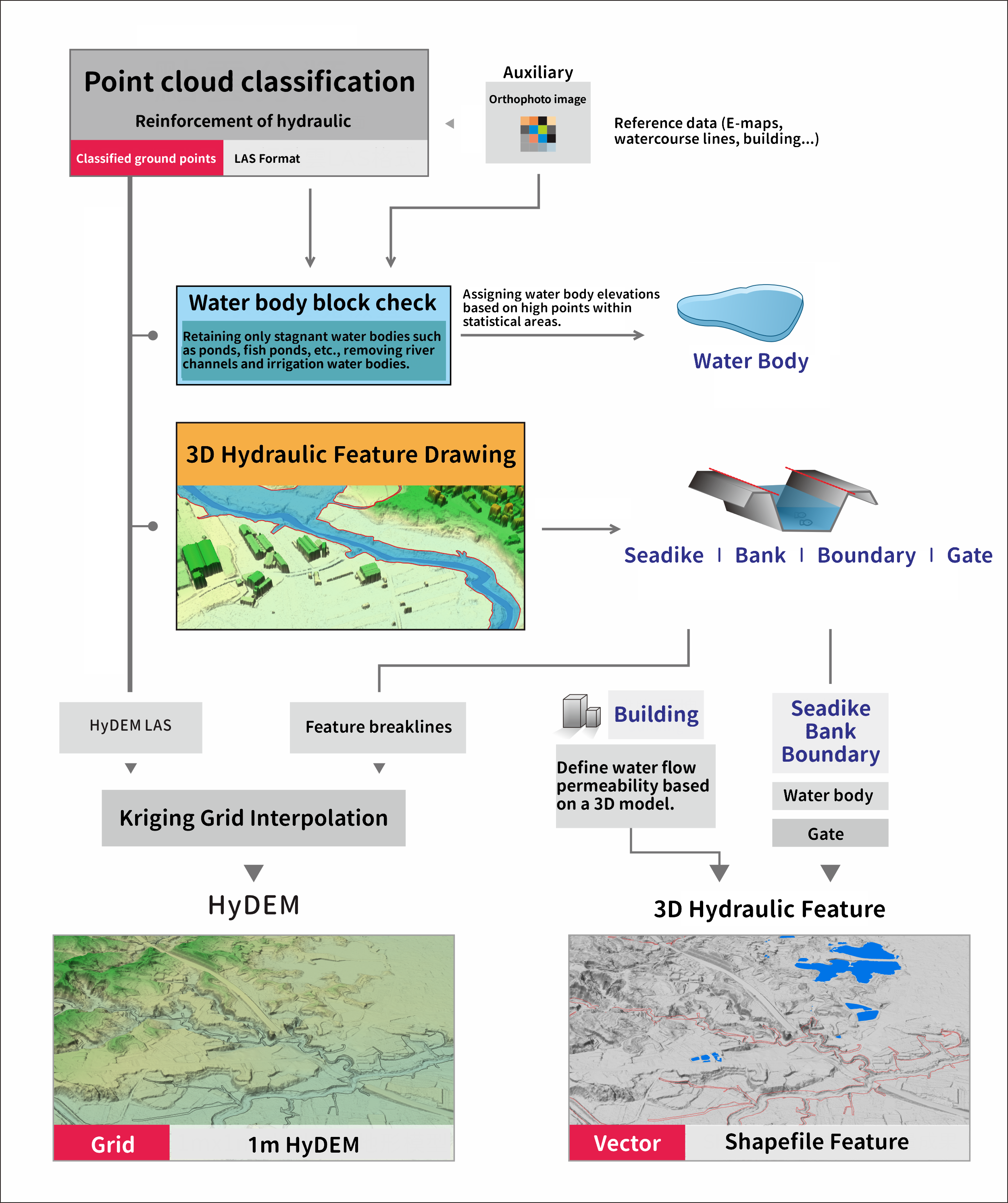
The Hydrologic Topography Dataset (HTD) includes three types of results: Hydraulic Digital Elevation Classification Point Clouds, 3D hydraulic feature, and Hydraulic Digital Elevation Models. The Hydraulic Digital Elevation Classification Point Clouds involve reclassifying the Ministry of the Interior’s airborne LiDAR point cloud data to ground points for artificial hydraulic structures like embankments on both sides of channels, floodwalls, breast walls, or guardrails with widths less than 1 meter. The classified point cloud data is then digitized to produce 3D hydraulic feature, which include five categories: building, bank, water body, sea-land boundary, sea dike, and gate. This data is further used to interpolate and produce a 1-meter grid Hydraulic Digital Elevation Model.
Since 2021, the National Land Surveying and Mapping Center of the Ministry of the Interior(NLSC) has been executing the HyDEM data production work. It is expected to complete the first round of measurements for the entire Taiwan region by 2024. We plans to carry out the second round of HyDEM measurement updates from 2025 to 2029. Related results can be accessed through the Ministry of the Interior's "DTM Data Supply Platform" (Link)
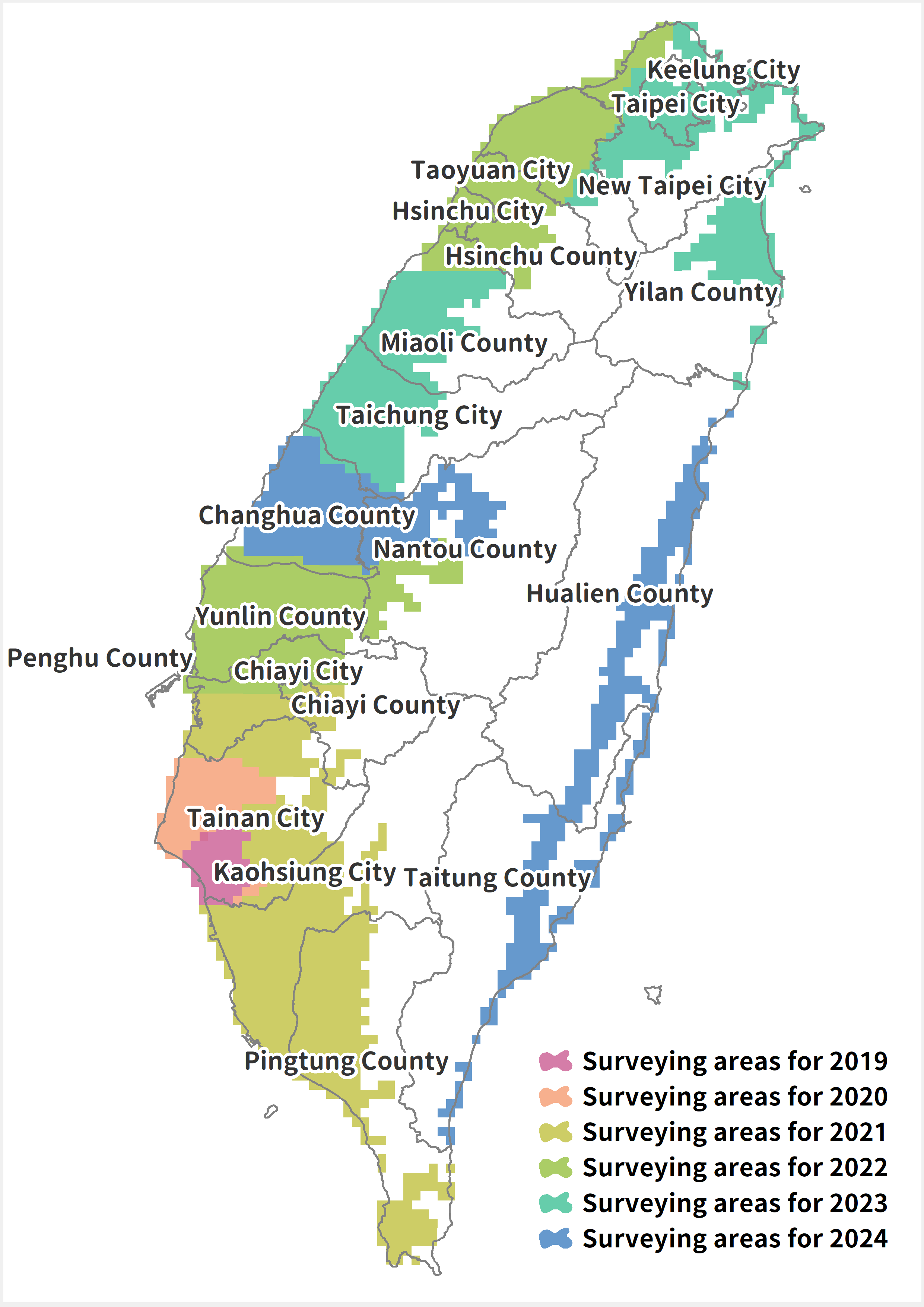
The number of completed HyDEM results from 2019 to 2024are listed in Table 1. The surveying areas for each year from 2019 to 2024 are shown in Figure 2.
Table 1 The Annual Number of HyDEM
|
Year
|
Number of HyDEM (1:5000 map sheets) |
Implementing Agency |
| 2019 |
52 |
MOI |
| 2020 |
100 |
MOI |
| 2021 |
650 |
NLSC |
| 2022 |
620 |
NLSC |
| 2023 |
559 |
NLSC |
| 2024 |
529 |
NLSC |
| Total |
2,510 |
- |

Figure 1 Flowchart of HyDEM

Figure 2 Surveying areas from 2019 to 2024